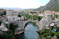
Mostar is the main cultural, economic and administration centre of Herzegovina. The first mention of Mostar dates back to 1440 and soon afterwards it took the primacy from Blagaj, formerly the capital of Herzegovina. The town is well known for its Old Bridge, the construction of which began in 1557 and lasted for nine (9) years. The name of Mostar derives from the word “mostari” (the bridge keepers) who guarded the Old Bridge. The Old Bridge stood for 427 years, until the bridge was destroyed on November 9, 1993 by the HVO artillery. The Bridge was reconstructed in 2004 and has been under the UNESCO protection since 2005. Distance from the camp: 12km, cca 10 minutes by vehicle. GPS: 43°20'6.25"N - 17°48'46.90"E
Orthodox monastery of Žitomislići is one of the most significant cultural monuments in terms of the orthodox monasteries built in the 16th century in Bosnia and Herzegovina. It is located in the valley leading from Mostar to the southern BiH border crossing.
GPS: 43°12'12.78"N - 17°47'34.19"E
Počitelj is a very attractive mediaevel town located in the valley of the R iver of Neretva . It most certain l y presents one of the most valuable cultural and historical monuments in Bosnia and Herzegovina. As one of the great strategic points of the Turkish Empire, Počitelj shapes a strong mediaeval fortress with a terrace-like layout on the slopes of a hill. It is located nearby the town of Čapljina on the left bank of the Neretva. Distance from the camp: 25 minutes, M17 highway Mostar-Metkovi ć route.
GPS: 43° 7'8.97"N - 17°44'15.61"E
Medieval necropolis at Radimlja is situated at Vidovo Polje Valley, 3km west from the town of Stolac, at Čapljina-Stolac route. The necropolis at Radimlja is one of the most ornamented grave stone grounds in BiH. By artistic standards it may be placed amongst the most valuable medieval necropolises at all.
GPS: 43° 5'25.01"N - 17°55'36.52"E
Hutovo blato is a natural resort park and bird refuge in Bosnia and Herzegovina. It covers an area of almost 8 hectares within the valley of the Neretva. Visiting this park is free of charge and apart from site seeing and photo-safaris, there are many other exploration opportunities and tourist attractions.
GPS: 43° 3'5.69"N - 17°44'40.69"E
Kravice waterfalls are located 3km downstream the Vitaljina, in Studenci nearby the town of Ljubuški. The Trebižat river, with its marvelous course, creates the waterfalls. The height of the waterfall is around 28m, with a lake below that falls of 120m in radius.
GPS: 43° 9'11.00"N - 17°38'16.00"E
Mogorjelo is a unique archeological site of the Roman culture with a well-preserved old Roman “villa rustica”. It is located in the vicinity of Čapljina, southern area of Bosnia and Herzegovina. This cultural monument is one of the most beautiful sites of the late Roman architecture in the whole of Bosnia and Herzegovina.
GPS: 43° 5'57.11"N - 17°41'58.62"E
Međugorje is one of the most famous catholic shrines in the world. It is located nearby Č itluk, the southern area of Bosnia and Herzegovina. The population of Me đ ugorje currently numbers about 4300 inhabitants. Međugorje became very popular back in 1981 when The Blessed Virgin Mary ‘s apparitions began.
GPS: 43°11'28.74"N - 17°40'40.53"E
Podveležje is a lovely hiking site for its natural vicinity to Mt. Velež, which at its 1,900m makes the highest mountain peak in the region. It is located at only 10km distance from Mostar. Podveležje has recently been given a status of an eco zone.
GPS: 43°20'39.31"N - 17°53'56.73"E
Rujište is an ideal place for any visitor who wants to exchange the Mediterranean climate for one of a bracing mountain with beautiful slopes and rich hunting grounds. It is located at the perrifery of Mt. Prenj and Mr. Velež (some 3,300 ft. above the sea level, highest peak of the six in total, 2155m called Zelena glava ). As such, Rujište makes a perfect start for mountaineers to clime the mountain of Prenj.
GPS: 43°27'51.73"N - 17°57'39.43"E